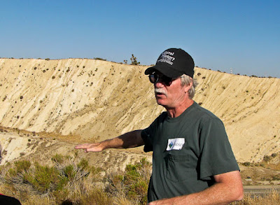
Our guide was Lindsey Groves, a colleague of Leslie's at the Museum. This is Lindsey. When he talks he uses his hands a lot.

Behind him, on the opposite side of the Antelope Valley Freeway, just north of the San Andreas Fault, you can see the wall of a freeway cut. A cut is where they excavated a hill to avoid having to build the freeway over it. This one is just north of Avenue S near Palmdale. Notice the vertical lines called strata. These were formed horizontally and then pushed upward by earthquakes. All the pushing took a very long time.
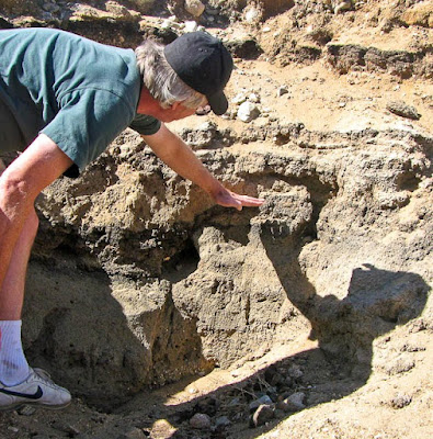
The next picture shows Lindsey in the middle of nowhere at a place called Pallet Creek. He is showing us where layers of sediment in a former lake bed have been toyed with by earthquakes. With his hand he's marking the level of a dark layer of peat which was moved upward by a quake. Notice that the dark band to the left of his hand is lower. An earthquake once broke the earth exactly at this spot.

When asked exactly where the fault line is now Lindsey would only point out a several hundred foot span. The next time the earth moves on the fault it'll be somewhere within that swath - probably. He seemed to enjoy pointing out structures which just might be straddling the San Andreas Fault.
At one point on the road, not far from this Pallet Creek site and not far from the fault itself, a band of helpful Boy Scouts erected a San Andreas Fault sign. This served as an excellent photo-op. Here's Leslie near the sign.

The tour began at Devore where several earthquake faults, including the San Andreas, meet with several freeways and several major railroad lines. Recipe for disaster? Then we moved to Wrightwood a town in the mountains. It sits right on the fault, nestled in tall pine trees.
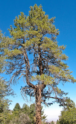
Near Wrightwood are Earthquake Trees. These trees had their tops snapped off long ago during the earthquake of 1812. They kept on growing afterwards but with two trunks instead of one.

We lunched in an idyllic place called Jackson Lake, thick with green reeds and noisy with ducks. We saw many small lakes on the tour. These bodies of water are the result of seismic movement. Geologists use them as clues to where the fault lines are.

Indeed, picking an earthquake fault out of a scenic vista is difficult, although the geologists have their little tricks. But identifying a fault zone precisely takes careful measurements with precision instruments. It may be hard to see but we know it could cause a lot of damage. Preparedness is important.
I thought this is similar to certain medical conditions like high blood pressure, high cholesterol or high blood sugar. You only can tell you have these diseases because doctors use their machines to identify them. You can't feel the illness, but it could do you a lot of damage. It's a good idea not to ignore them.
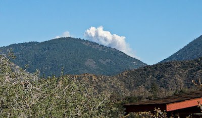
We visited Devil's Punchbowl, just one of several fantastic rock formations caused by seismic shifts. Devil's Punchbowl had been in great danger from the recent Station Fire. A pyro-cumulus cloud was just poking out over the mountains when we visited. A new fire had started several hours earlier somewhere in the area we had just visited. As we watched the cloud kept getting bigger.

This new fire (still burning as I write this) is called the Sheep Fire. It has now burned a large area which we visited along the San Andreas Fault.
Yes, there are a lot of dangers to living in Southern California. Earthquakes and fires are just two of them. Neither is easy to predict. Both can be devastating to lives and property. The similarities end there.
On a lighter note, at Devil's Punchbowl some local wildlife was on display - including three owls. Here's Owl Number Three.

Several of the links above connect to Google maps. In these the fault generally moves from upper left to lower right. There are some clues visible from satellite pictures which can't be seen from the ground.
I also suggest you visit geology.com where you can see Google maps with the San Andreas fault indicated using geopositioning data. I couldn't find a way to link to particular locations on those maps, however, so you'll have to navigate manually.
Lindsey Groves works at the Malacology department of the Natural History Museum of Los Angeles County. His interests also include geology and paleontology. He wrote a fantastic article about the San Andreas tour for the museum's magazine. Hopefully I will find an online link to that. Hopefully he'll forgive me for the liberties I've taken in describing his interesting field trip.
Fault Tags: San Andreas Fault. . . NHMLAC. . . Lindsey Groves. . . earthquake. . . forest fire. . . Southern California
1 comment :
You've given a reason as to why certain pines grow in a fork. Sad to think so many of these old pines are not dust.
Devils Punch bowl is a favorite location of mine. It's facilities are charming.
Jackson Lake is where I picnicked on my 40th birthday.
Post a Comment